
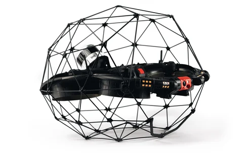
Testing the Elios 3 Surveying Payload: Mapping a 600m Bridge Without Disrupting Traffic
Flyability, in collaboration with partner Droprise, recently put the Elios 3 and its new LiDAR surveying payload to the test during a bridge inspection in Belgium. This innovative project showcased how drones can revolutionize infrastructure monitoring while ensuring safety, efficiency, and precision.
|
Safety The Elios 3 was able to access the entire 600-meter bridge without requiring any scaffolding or elevated work platforms. The drone safely navigated around the structure, avoiding any potential hazards and ensuring that traffic remained undisturbed throughout the operation. |
Efficiency Thanks to the advanced capabilities of the Elios 3, the team completed the survey in just four flights within a single day. This rapid data collection minimized downtime and allowed for immediate analysis, reducing the need for future site visits and saving both time and resources. |
|
Accuracy The Surveying Payload achieved over 90% accuracy within 1 centimeter, delivering highly detailed point cloud data. This level of precision is ideal for identifying structural issues, wear, and tear, which can inform maintenance decisions before more severe problems arise. |
Business Development Despite not flying directly over the bridge deck, the team was able to create a full 3D model of the entire structure. This approach demonstrated the versatility of the Elios 3 and the Surveying Payload, proving their value in real-world scenarios where traditional methods would be impractical or dangerous. |
Flyability launched the Elios 3 Surveying Payload in October 2023, aiming to offer a powerful LiDAR solution for infrastructure inspections. With the help of Droprise, they tested the system on a real-world bridge, showcasing its ability to collect high-quality data quickly and safely.
Understanding the Elios 3 LiDAR Payloads
The Elios 3 offers two LiDAR configurations, each tailored for different use cases. The standard Rev 6.2 LiDAR is ideal for general surveys where moderate accuracy is sufficient. However, the Surveying Payload, equipped with the more advanced Rev 7 LiDAR, is designed for high-precision mapping in complex environments such as tunnels, pipelines, and bridges.
This new payload significantly improves upon previous models, offering faster scanning speeds, better range, and enhanced data quality. With 1.5 million points per second and a range of up to 100 meters, it delivers exceptional detail, making it perfect for infrastructure monitoring and asset management.
 The new Elios 3 LiDAR payload expands the possibilities of drone-based mapping
The integration of FARO Connect software further enhances the workflow by enabling automated point cloud merging and noise reduction, streamlining the post-processing stage. This makes the data not only accurate but also easier to interpret and use for decision-making.
In October 2023, Flyability and Droprise took the Surveying Payload out for a real-world test at a busy motorway bridge in Belgium. The goal was to demonstrate its effectiveness in a practical setting, especially in areas where traditional methods are either too costly or unsafe.
Completing a Road Bridge Survey Without Stopping Traffic
Droprise has been a long-time partner of Flyability since 2019, working on various drone inspection projects across construction and infrastructure sectors. Their mission was to showcase the Elios 3’s capabilities in a way that would appeal to potential clients—especially those who require proof of ROI before adopting new technology.
The team obtained permission to inspect key parts of a 600-meter-long bridge, but they were not allowed to fly directly over the live road. Instead, they focused on gathering data from underneath and alongside the structure, creating a complete 3D model of the entire bridge.
A successful bridge survey using the Elios 3 Surveying Payload
The Elios 3's unique design allows it to operate without GPS, relying instead on visual-inertial odometry (VIO) and LiDAR stabilization. This makes it ideal for navigating tight spaces and areas with poor GPS reception, such as under bridges or inside tunnels.
During the survey, the pilots carefully planned their flight paths to avoid distracting drivers. They flew at specific angles and heights, ensuring safety while still capturing all necessary data. The results were then processed using FARO Connect, aligning multiple flights into a single, accurate 3D model.
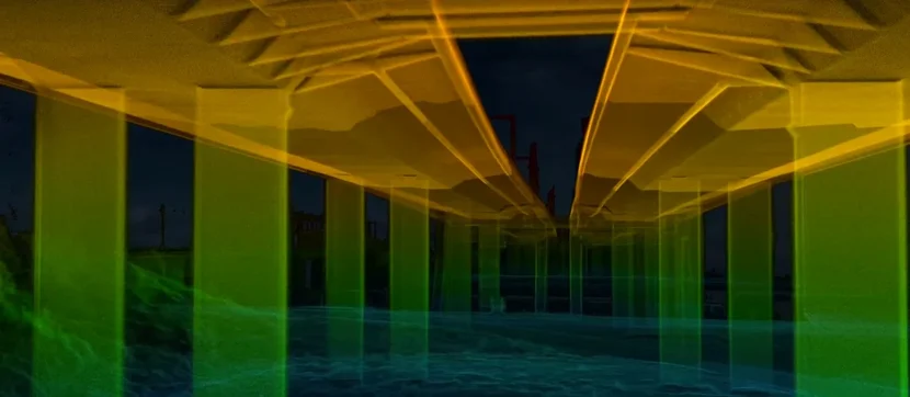
Watch the incredible LiDAR results captured during this bridge scan
The 600-meter-long bridge was fully mapped in just four flights, with the Rev 7 LiDAR capturing an impressive 1.5 million points per second. The resulting point cloud provided a clear and detailed representation of the structure, even from limited angles.
Results of the Bridge Survey with the Elios 3
The final 3D model of the bridge demonstrated the power of the Elios 3 and its Surveying Payload. Despite being scanned from a few angles, the data was rich in detail, allowing for thorough analysis of the structure’s condition.
Droprise now has a compelling case study to present to potential clients, highlighting the benefits of drone-based inspections in infrastructure management. Looking ahead, they plan to conduct a follow-up flight that will incorporate georeferencing to achieve even greater accuracy, leveraging the Surveying Payload’s capabilities and FARO Connect’s automation.
flange cover
Taixing Yingxing Composite Material Co.,Ltd , https://www.ptfecnyx.com