
What Is a GPS-Denied Drone?
A GPS-denied drone is a type of unmanned aerial vehicle (UAV) that can navigate and operate effectively in environments where traditional GPS signals are unavailable or unreliable. Instead of relying on satellite-based positioning, these drones use advanced onboard sensors to perceive their surroundings and maintain stability.
Most modern drones depend on the Global Positioning System (GPS) for navigation and hover control. While GPS-enabled drones are generally safe, accurate, and reliable, they face limitations when used indoors or in areas with signal interference. This has led to an increasing demand for drones that can function without GPS, especially in professional and industrial settings.
As drone technology continues to evolve, industries such as mining, oil and gas, power generation, and infrastructure inspection are turning to GPS-denied drones for more efficient and safer operations. These drones are capable of flying in confined spaces, such as tunnels, storage tanks, and power plants, where GPS signals are weak or absent.
Industries like pharmaceuticals, wastewater management, and even search and rescue operations also benefit from GPS-denied drones. These drones offer greater flexibility, safety, and accuracy in environments where traditional GPS systems would fail.
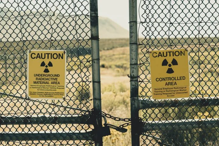
One key reason many organizations prefer GPS-denied drones is security. In sensitive locations such as nuclear power plants, some operators avoid using GPS due to concerns about potential vulnerabilities or data leaks. A GPS-denied drone eliminates this risk entirely by not requiring any external signal for navigation.
NASA has highlighted the importance of GPS-independent drone capabilities, stating that future drone technology must be able to operate even if GPS signals are lost. This is particularly crucial in urban areas where GPS signals can be disrupted at low altitudes—precisely where high precision is most needed.
How Can Drones Fly Without GPS?
GPS-denied drones rely on a combination of onboard sensors, including optical cameras, LiDAR (Light Detection and Ranging), and inertial measurement units (IMUs) to navigate and map their environment. These sensors work together to create real-time maps, track movement, and maintain stability without the need for GPS.
For example, optical sensors act as the drone’s “eyes,†capturing visual data to help it understand its surroundings. LiDAR, on the other hand, uses laser pulses to measure distances and generate detailed 3D models of the environment. Together, these technologies allow the drone to fly autonomously, avoid obstacles, and perform complex tasks in GPS-challenged areas.
LiDAR technology is particularly valuable in environments with limited visibility, such as dense forests, underground tunnels, or inside large industrial structures. It allows drones to "see" through obstacles and create accurate 3D representations of their surroundings, making them ideal for inspections, mapping, and search and rescue missions.
By combining visual recognition with LiDAR, drones like Flyability’s Elios 3 can navigate tight spaces and capture high-resolution images and videos. This makes them essential tools for inspecting hard-to-reach areas, such as wind turbines, bridges, and pipelines.
When Is a GPS-Denied Drone Necessary?
While GPS-denied drones may seem like a niche technology, they are becoming increasingly essential in a wide range of applications. Here are eight scenarios where they are particularly useful:
1. Indoor Inspections
Many industrial facilities, such as power plants, refineries, and chemical plants, have large metal structures that block GPS signals. GPS-denied drones are ideal for inspecting boilers, pressure vessels, and storage tanks, where traditional drones would struggle to maintain stable flight.
2. Critical Infrastructure
Drones used for inspecting military bases, dams, and power plants often require secure and reliable navigation. GPS-denied drones eliminate the risk of signal interference or data leaks, making them a preferred choice for sensitive locations.
3. Wind Turbine Inspections
Wind turbines are large, complex structures made of metal, which can interfere with GPS signals. GPS-denied drones can navigate the internal components of turbines, allowing for more accurate and efficient inspections.
4. Bridge Inspections
Concrete and steel bridges can disrupt GPS signals, making it difficult for traditional drones to operate safely. GPS-denied drones provide a reliable alternative for inspecting bridge structures and identifying potential issues.
5. Maritime Inspections
Inside cargo holds and fuel tanks, GPS signals are often blocked by thick metal walls. GPS-denied drones can access these areas safely, reducing the need for manual inspections and improving operational efficiency.
6. Mining Operations
Mining environments, especially underground, are often devoid of GPS signals. GPS-denied drones can explore tunnels and collect data in hazardous conditions, improving safety and reducing costs.

7. Search and Rescue
In dense forests or mountainous regions, GPS signals can be weak or completely lost. GPS-denied drones ensure continuous operation, helping rescuers locate missing persons in challenging environments.
8. Disaster Response
After natural disasters, debris and damaged structures can block GPS signals. GPS-denied drones can navigate through rubble and provide critical visual data, aiding in recovery efforts and saving lives.
Industries That Use GPS-Denied Drones
GPS-denied drones are being adopted across various sectors, including:
- Oil & Gas
- Power Generation
- Chemical Storage
- Mining
- Water and Sewer Management
- Public Safety
- Infrastructure (bridges, tunnels, etc.)
- Steel Manufacturing
- Maritime (ships and supporting infrastructure)
Benefits of Using a GPS-Denied Drone
There are numerous advantages to using a GPS-denied drone, including:
- Operation in any environment, regardless of GPS availability
- Improved accuracy and detail in inspections using LiDAR and 3D mapping
- Safety in dangerous or hard-to-reach areas
- Remote data collection, reducing human exposure to risk
- High-resolution imaging and video for detailed analysis
- Cost savings through faster and more frequent inspections
- Reduced personnel and resource requirements
- Minimized downtime for critical infrastructure
Use Cases for GPS-Denied Drones
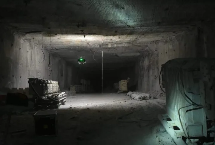
Stockpile Measurements Improve Safety & Accuracy at Salt Mine

Industry: Mining
Mission: To calculate the amount of salt present at a salt mine in Germany using LiDAR data collected by Flyability’s Elios 3 indoor drone.
Results: Using the Elios 3, personnel at the mine were able to collect all the data they needed to perform the stockpile measurement without endangering anyone.
GPS-Denied Drone Significance: Because the mission was underground, a drone that relied on GPS would never have been able to operate in the environment. Therefore, a GPS-denied drone like Flyability’s Elios 3 was required for the work.
Read the full case study.
$2 Million Saved Using Drone for Oil Tanker Cargo Inspection

Industry: Maritime
Mission: To analyze a crack detected in the cargo tank and determine the extent of the damage to help develop a repair plan. The inspection was performed by Inspection Service Ltd., which chose the Elios 2 because it eliminates the need for building scaffolding and putting workers in a dangerous environment.
Results: Using the Elios 2, inspectors were able to locate the crack and assess the damage quickly. The visual data was also used to identify other areas on the ship where defects may be present. After a review, two more similar cracks were detected in other areas of the ship. Had these cracks been identified later, they would have resulted in expensive repairs and downtime.
GPS-Denied Drone Significance: Without GPS-denied navigation, inspecting the oil tank via drone would have been nearly impossible. The tank's location and the ship's metal structure are not favorable conditions for a regular drone. With built-in SLAM drone sensors, the Elios 2 made quick work of the tank inspection.  Â
Read the full case study.
3D Maps Help Mining Operation Find Cause of Ore Pass Hangup in 10 Minutes

Industry: Mining
Mission: Personnel at a major mining operation in Colorado encountered a large hangup in an ore pass that was so big it was preventing any ore from falling down the pass.Â
Results: After two months of exploratory drilling and blasting mining personnel still couldn’t diagnose the problem. But with the help of the Elios 3’s 3D Live Map, they were able to see the cause of the hangup and its exact location in just ten minutes.
GPS-Denied Drone Significance: As with the stockpile measurement at a salt mine covered above, this mission was entirely underground, making the use of a drone that relied on GPS impossible. Only a GPS-denied drone would have been able to operate in the ore pass in order to find the cause of the hangup.
Read the full case study.
One Month of Work Saved On Complex Nuclear Inspection

Industry: Power generation
Mission: Conduct a visual inspection of an ASME XI nuclear facility spanning 40,000 square feet. The goal of using an autonomous drone was to reduce this resource-intensive task's dangers, time, and expense. Â
Results: Using the Elios 2, the inspection saved over 300 billable hours by speeding up inspection completion by one month and reducing the required qualified inspectors by 2. The team achieved 100% coverage of this enormous structure with detailed photographs and data.Â
GPS-Denied Drone Significance: Nuclear power plant structures are primarily built with concrete, steel, and other materials known to cause signal interference. With SLAM drone technology, the signal problems and national security concerns regarding drones and critical infrastructure are significantly reduced.
Read the full case study.
Essential Oil Room Diffuser,Non Electric Oil Diffuser,Scented Oil Diffuser Electric,Decorative Essential Oil Diffuser
Guangzhou Chiyang Scent Technology Co., Ltd. , https://www.diffuserscent.com